ENGINEERING SEISMOLOGY
Solution of Engineering Tasks: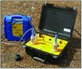
- Model analysis of buildings and structures (according to natural periods and forms);
- Determination of vibration levels (according to sanitary, technological, construction and other standards);
- Assessment of damage of buildings and structures (in case of natural and technogenous catastrophes);
- Licensed softwares EZFRISK, Openquake, ELER V3, which enable solving the following tasks:
- Probabilistic assessment of seismic hazards at maximum and spectral acceleration;
Disaggregation of seismic hazards; - Deterministic assessment of seismic hazards, constructing earthquake scenarios;
Tasks of Engineering Seismology; - Evaluation and verification of design seismicity of the building area;
HYDROGEOPHYSICS AND GEOTHERMY
Study of underground water resources, determination of their age and dynamic regime by modern hydrogeophysical methods for elimination of environment pollution and creation of renewable energy sources
- Determination of underground water flow directions and assessment of pollution by use of stabile and radioactive isotopes as tracers;
- Determination of surface depths and spatial locations of aquifer horizons by geological and geophysical methods;
- Determination of filtration properties by field testing method for aquifer horizons;
- Determination of thermal parameters and thermal flow in rocks for geothermal deposits;
- Building and calibration of 3D conceptual deposit models;
- 3D digital modeling by licensed modern softwares FeFlow, VisualModFlowPro, etc. for defining the pollution sources, evaluating their resources and determining economically and ecologically reasonable long-term exploitation conditions (see page 6);
- Multiparameter monitoring on main deposits, key aquifer horizon points, drinkable, mineral and thermal waters for determining and controlling the nature of variation of parameters in space and time; study and forecasting of the development of hydrogeologic, ecologic and seismic processes.
ENGINEERING GEOPHYSICS
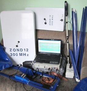
Determination of geologic structures of building areas, study and elimination of the risks of landslides, mudfloods and other hazardous exogenic processes by (seismic, electrical, magnetic, georadiolocation) methods of Engineering Geophysics.
Automatic telemetric systems for deformation monitoring and early warning systems for large engineering objects (at the Enguri international geodynamic test area).
Geophysical investigations for reconstruction of Pushkin street in Tbilisi - three main layers are distinguished in seismic sections. The results are fully confirmed by the borehole data.
Georadiolocation (GEORADAR) in
Building Control and Engineering Archaeology
 GEORADAR is used for precise detecting of reinforcement, pipes, cables, voids and damaged areas without boring, which is useful during reconstruction works. GEORADAR is more often used nowadays for quick localization of hidden objects on huge building areas. Archaeogeophysics enables cost-effective precise determining of locations, surface depths, measurements and other details of hidden objects (monuments).
GEOECOSECURITY
There are plenty of hazards in our days, which endanger your life and property.
Before starting some construction project or buying some object you should know how resistant the construction site or building is to environmental risks (earthquakes, landslides, floods and flashfloods, etc). Professionals will give you valuable recommendations – they will establish the potential risks for your office or your dwelling.
All information will be given as a relevant certificate, where the level of hazard and risk as well as the detail recommendations for reducing object’s vulnerability to a given hazard.
We’ll establish:
Seismic hazard (distance from the nearest big active fault, expected shaking intensity, PGA, PGV, PGD, spectral acceleration);
Mapping of multi-hazards (12 hazards);
The state of foundation, construction and soil (their stability);
The level of radiation, radon concentration;
The level of electromagnetic radiation;
The level of noise;
The composition/age and quality of water;
The quality of air;
The risk of landslide, debris flow, avalanche and subsidence/liquefaction;
Geomagnetic prognosis;
Optimal system for automatic telemetric monitoring.
Institute of Geophysics periodically gives seminars on the spheres of geophysical investigation for all interested persons.
DAMAST – Technologies for Safe and Efficient Operation of
Hydropower Reservoirs 2019 -2022
Dear colleagues,
December 12-14, 2019 the Iv. Javakhishvili Tbilisi State University the International Scientific Conference on the theme „Natural Disasters in Georgia: Monitoring, Prevention, Mitigation“ is conducted.
The conference is dedicated to the 175 and 120 Anniversary of the Organization in Georgia of Regular Magneto-Meteorological and Seismological Observations.
.
We invite you to participate in the conference!
Website: http://4science.ge/conferences/index.php/CONF/CONF
E-mail: ndgconference@4science.ge
Contact persons:
Nino Berianidze – E-mail: nikoli700@yahoo.com , Mob.: +995 598 30 36 00
Manana Nikolaishvili – E-mail: manananikola@gmail.com , Mob.: +995 557 23 62 90
Mikheil Pipia – E-mail: m.pipia@gtu.ge , Mob.: +995 593 55 65 11
Attachments: 1. The First Information Letter, 2. Registration Card , 3. Requirements for Article Design (3 files).
Organizing committee
Applied Geophysics in Construction
- Geological and geophysical exploration of building sites of constructions – highways, railways, bridges, tunnels, dams, hydropower stations and other engineering objects (sections, maps);
- Demarcation of landslides, compilation of sections, delineation of karsts and tunnels;
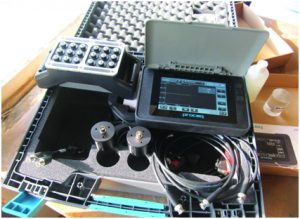
- Investigation of damage in foundations, piles and other engineering constructions; monitoring of deformations of buildings by precise tiltmeters; emergency assistance;
- Prospecting of mineral deposits and calculation of reserves;
- Prospecting for underground waters and measurements of ground water level/dynamics, age; compilation of three-dimentional hydrogeological computer models, localization of water leakage;
- Planning and optimal management of geothermal systems;
- Determining mechanical properties of the soil at building sites by elastic cross wave method (Vs30) up to 30m depth;
- Exploration of buried archaeological monuments;
- Geological security (see the following page);
Measuring elastic properties of rocks and building materials by thermal and ultrasonic method; - Checking concrete quality by ultrasonic method;
Geophysical investigations do not harm buried monuments.
The investigations are performed in the shortest time, which is due to using modern exploration equipment and methodology and visualization of data by modern computer programs.
The exploration method (seismic, electromagnetic, magnetic) or a set of methods will be chosen according to the target task. Besides land service the investigation from boreholes or pits is possible. Detailed description of geophysical investigation methods is given below.
The investigation reports are completed with: Graphical material (schemes, sections, maps in GIS); Tables (physical and mechanical properties of rocks, GSI); Digital presentation, 2- and 3-dimensional visualization; Translation to other languages.
RESULTS OF GEOPHYSICAL INVESTIGATIONS
-
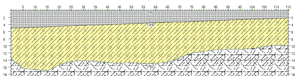
- Seismic section
-
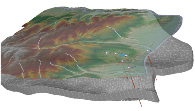
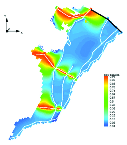
- Digital 3D modeling of hydrothermal basin
-
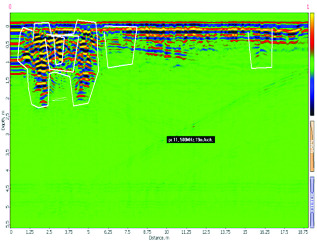
- Section obtained by GEORADAR (Khoby Monastery)
-

- Geological-geophysical section (seismic and electrical prospecting)
-

- Geo-hazards and risks mapping. Computer model of hazardous natural phenomena (mudflows, landslides) by Pan-European (GIS) map standard.
-
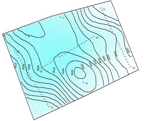
- Map of rock surface depth and longitudinal wave velocity
-
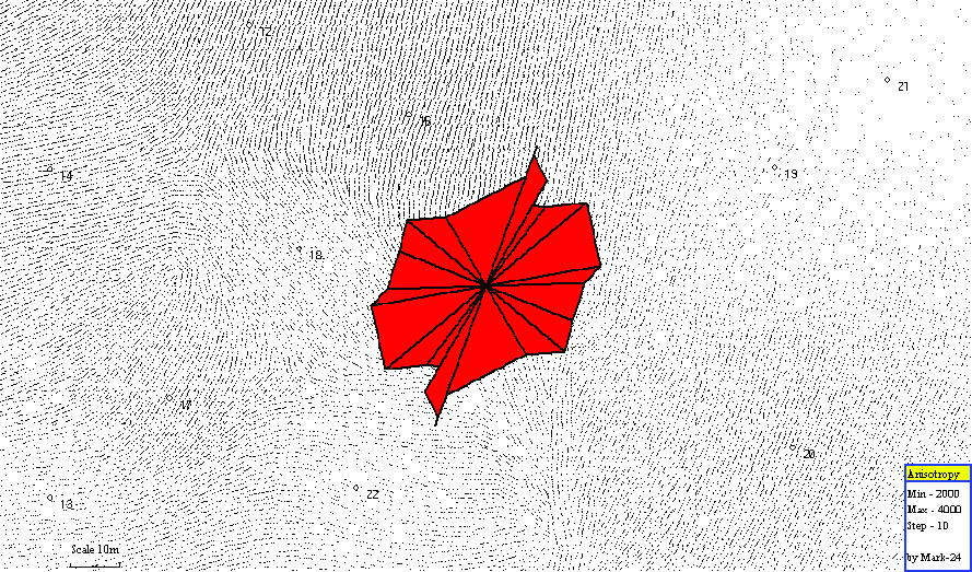
- Map of bed-rock crack anisotropy (natural potential method)
-
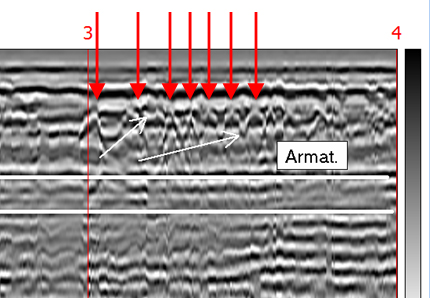
- Detecting reinforcement localization by GEORADAR in BATUMI tunnel
-
- Modeling of heavy metals distribution in surface waters (Poladauri river gorge)
